
Story By PETER B. de SELDING, Space News Staff Writer from Space.com, June 8, 2007,
http://www.space.com/news/060707_graves_web.html
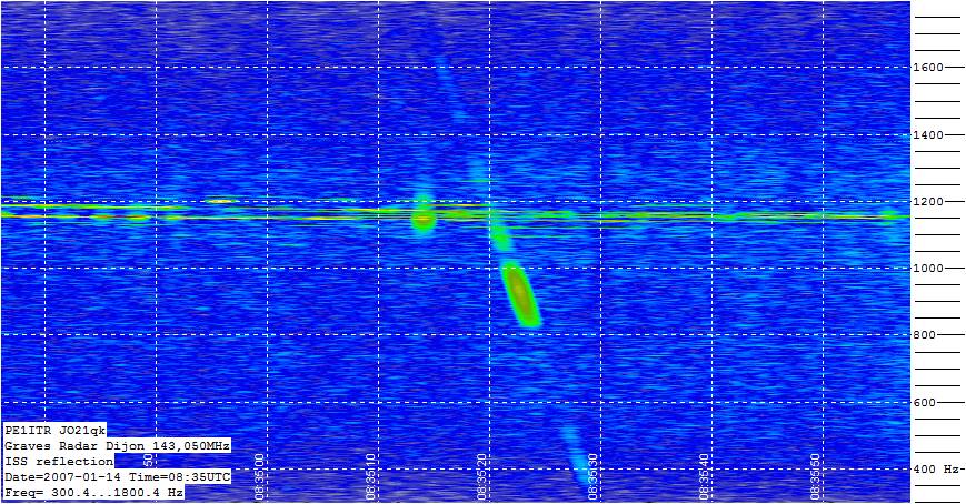
Blognote: The Graves French Space Surveillance radar is located near Dijon, France and operates on 143.050 MHz. It uses a powerful transmitter transmitting a continues wave carrier. Here is a screenshot of the ISS crossing the Graves RF fence courtesy of of Paul J. Marsh at
http://www.pe1itr.com/graves/capt0701140741.jpg. According to Paul There are four antenna beams "sweeping" there sectors. The Graves sourcebook gives good info about the radar at http://www.fas.org/spp/military/program/track/graves.pdf.
A French space surveillance radar has detected 20 to 30 satellites in low Earth orbit that do NOT figure in the U.S. Defence Department's catalogue.
After 16 months operation of its Graves radar system, which can locate satellites in orbits up to 1,000 kilometres in altitude, the French Defence Ministry says it has gathered just about enough information to pressure U.S. authorities to stop publishing the whereabouts of French reconnaissance and military communications satellites.
The U.S. Defense Department's Space Surveillance Network is the world's gold standard for cataloguing satellites and debris in both low Earth orbit and the higher geostationary orbit at 36,000 kilometres in altitude, where telecommunications satellites operate.
Data from the U.S. network of ground-based sensors are regularly published and used worldwide by those tracking satellite and space debris trajectories. The published information excludes sensitive U.S. defence satellites, but regularly includes data on the orbits of other nations' military hardware.
The Graves radar, and a complementary system operated by the German government, together are enough to pinpoint the location, size, orbit and transmission frequency of satellites - data which the U.S. would prefer not to be broadcast worldwide, French officials said.
'We have discussed the Graves results with our American colleagues and highlighted the discrepancies between what we have found and what is published by the US Space Surveillance Network,' said one French defence official. 'They told us, "If we have not published it in our catalogue, then it does not exist." So I guess we have been tracking objects that do not exist. I can tell you that some of these non-existent objects have solar arrays.'"
 GRAVES - The French Space Surveillance System
 According to the American space catalog, more than 9,000 satellites or objects larger than ten centimeters are orbiting the Earth. Many of these overfly France daily, constituting a potential threat for the country. Until now, only the Americans and Russians have had an operational space surveillance system. In the early nineties, Onera proposed an independent system dubbed "Graves" for this, to watch satellites in low orbit (altitude less than 1,000 km).
The Graves system was developed under DGA contract and consists of a specific radar combined with an automatic processing system that creates and updates a database of the orbital parameters for the satellites it detects.
The Graves radar was specifically designed for space surveillance in cooperation among DEMR and DPRS specialists. The priority objective was to design a low-cost system, both in terms of development and maintenance. This led to an original bistatic radar concept with electronic scanning and continuous VHF band emission. The reception system is based on Doppler detection, and uses an innovative beam formation technique, by calculation. Using very conventional technology subassemblies, making it reliable and maintainable, radar performance is based on high-level signal processing requiring all the power of a dedicated real-time computer.
Downstream of the radar, a major effort was made to develop programs to convert the raw measurements into an orbital parameter database. This was a very ambitious technical challenge because, contrary to the American system that uses many sensors distributed around the globe, the tools developed for the Graves system only process the measurements from a single sensor.
After 15 years of work, the Graves system was delivered to its end user, the Air force, in November 2005. Operational since then, it has been keeping a database of some 2,000 satellites up to date. For a few dozen "sensitive" satellites, the U.S. does not publish the corresponding orbital elements.
